A GIS-based Spatial Multi-criteria Approach for Flash Flood Risk Assessment in the Ngan Sau-Ngan Pho Mountainous River Basin, North Central of Vietnam DOI: 10.32526/ennrj.18.2.2020.11
Article Sidebar
Main Article Content
Abstract
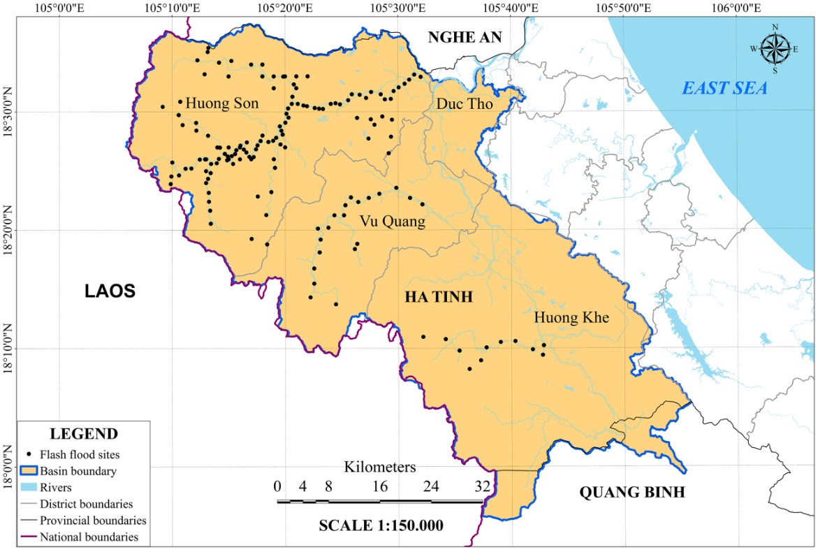
Flash flood risks in the Ngan Sau-Ngan Pho mountainous river basin (north central of Vietnam) were examined based on GIS and a spatial multi-criteria approach. A set of indicators were firstly proposed for the assessment of hazard, exposure and vulnerability. Analytic hierarchy process (AHP) technique and Iyengar and Sudarshan's method were then applied for calculating weights of hazard and vulnerability indicators, respectively. Flash flood risks were assessed by means of the “risk triangle” approach and were finally validated using past flood records. It was found that flash flood hazard was mainly at medium and low levels, with a very high hazard area of 178.6 ha accounting for 0.1% of the total river basin. Exposure at high and very high levels was mainly detected in the economic center of the basin. The high and very high vulnerability areas accounting for 98.2% of the total area were mainly concentrated in mountainous areas. The largest area was low risk totaling 219,083.1 ha (accounting for 68.6% of the basin area), followed by 67,148.6 ha (very low risk: 21%), 27,181 ha (medium risk: 9%), 5,909.7 ha (high and very high risks: 1.8%). These results demonstrate the proposed set of indicators, GIS and spatial multi-criteria analysis allow for effective flash flood risk assessment in mountains.
Article Details
Published articles are under the copyright of the Environment and Natural Resources Journal effective when the article is accepted for publication thus granting Environment and Natural Resources Journal all rights for the work so that both parties may be protected from the consequences of unauthorized use. Partially or totally publication of an article elsewhere is possible only after the consent from the editors.
References
2. Barredo JI, Engelen G. Land use scenario modeling for flood risk mitigation. Sustainability 2010;2(5):1327-44.
3. Bernstein L, Bosch P, Canziani O, Chen Z, Christ R, Riahi K. IPCC, 2007: Climate Change 2007: Synthesis Report. Geneva, Switzerland: IPCC; 2008.
4. Booij MJ. Impact of climate change on river flooding assessed with different spatial model resolutions. Journal of Hydrology 2005;303(1-4):176-98.
5. Brocca L, Melone F, Moramarco T. Distributed rainfall‐runoff modelling for flood frequency estimation and flood forecasting. Hydrological Processes 2011;25(18):2801-13.
6. Bucaram S, Fernández MA, Renteria W. Assessing local vulnerability to climate change in Rio de la Plata Basin, Uruguay. Compendium: Cuadernos de Economía y Administración 2016;3(6):1-19.
7. Chen Y-R, Yeh C-H, Yu B. Integrated application of the analytic hierarchy process and the geographic information system for flood risk assessment and flood plain management in Taiwan. Natural Hazards 2011;59(3):1261-76.
8. Committee of Earth Observation Satellite (CEOS). The use of earth observing satellites for hazard support: Assessments and scenarios. Final report of the CEOS disaster management support group (DMSG). Ann Arbor, USA: University of Michigan; 2003.
9. Crichton D. The risk triangle. Natural Disaster Management 1999;102:103.
10. Fernández D, Lutz M. Urban flood hazard zoning in Tucumán Province, Argentina, using GIS and multicriteria decision analysis. Engineering Geology 2010;111(1-4):90-8.
11. Field CB, Barros V, Stocker TF, Dahe Q. Managing the Risks of Extreme Events and Disasters to Advance Climate Change Adaptation: Special Report of the Intergovernmental Panel on Climate Change. NewYork, USA: Cambridge University Press; 2012.
12. Group B. Golden heart fund relieved flood victims in Ha Tinh province. Bitexco Group. [Internet]. 2016 [cited 2019 July 29]. Available from: http://bitexco.com.vn/newdetail/golden-heart-fund-relieved-flood-victims-in-ha-tinh-province-115.html.
13. Haberlandt U, Radtke I. Hydrological model calibration for derived flood frequency analysis using stochastic rainfall and probability distributions of peak flows. Hydrology and Earth System Sciences 2014;18(1):353-65.
14. Hiremath DB, Shiyani R. Evaluating regional vulnerability to climate change: A case of Saurashtra. Indian Journal of Agricultural Economics 2012;67(3):334-44.
15. Hong VT. Emergency response to flood in Huong Son, Ha Tinh. [Internet]. 2014 [cited 2019 July 29]. Available from: https://www.oxfamblogs.org/vietnam/2014/01/29/emergency-response-to-flood-in-huong-son-ha-tinh/.
16. Iyengar NS, Sudarshan P. A method of classifying regions from multivariate data. Economic and Political Weekly 1982; 2047-52.
17. Kazakis N, Kougias I, Patsialis T. Assessment of flood hazard areas at a regional scale using an index-based approach and Analytical Hierarchy Process: Application in Rhodope-Evros region, Greece. Science of the Total Environment 2015;538:555-63.
18. Kha DD, Nhu NY, Anh TN. An approach for flow forecasting in ungauged catchments: A case study for Ho Ho reservoir catchment, Ngan Sau river, central Vietnam. Journal of Ecological Engineering 2018;19(3):74-9.
19. Kia MB, Pirasteh S, Pradhan B, Mahmud AR, Sulaiman WNA, Moradi A. An artificial neural network model for flood simulation using GIS: Johor River Basin, Malaysia. Environmental Earth Sciences 2012;67(1):251-64.
20. Lee MJ, Kang JE, Jeon S. Application of frequency ratio model and validation for predictive flooded area susceptibility mapping using GIS. Proceedings of the Geoscience and Remote Sensing Symposium (IGARSS), 2012 IEEE International. International Congress Center, Munich: Germany; 2012.
21. Long B, Dung PT. Flash floods, hydrometeorological forecasting and warning systems in Viet Nam. Proceedings of the 7th Annual Mekong Flood Forum: Integrated Flood Risk Management in the Mekong River Basin; 2009.
22. Luu C, von Meding J, Mojtahedi M. Analyzing Vietnam's national disaster loss database for flood risk assessment using multiple linear regression-TOPSIS. International Journal of Disaster Risk Reduction 2019;40:101153.
23. Matgen P, Hostache R, Schumann G, Pfister L, Hoffmann L, Savenije H. Towards an automated SAR-based flood monitoring system: Lessons learned from two case studies. Physics and Chemistry of the Earth, Parts A/B/C 2011;36(7-8):241-52.
24. Meyer V, Scheuer S, Haase D. A multicriteria approach for flood risk mapping exemplified at the Mulde River. Germany Natural Hazards 2009;48(1):17-39.
25. Minh Thu, Chau T. Spring buds after floods. [Internet]. 2011 [cited 2019 July 29]. Available from: https://en.nhandan.org.vn/society/item/1665802-.html.
26. Myronidis D, Emmanouloudis D, Stathis D, Stefanidis P. Integrated flood hazard mapping in the framework of the EU Directive on the assessment and management of flood risks. Fresenius Environmental Bulletin 2009;18(1):102-11.
27. Nhan Dan Online (NDO). Floods cause severe damage in northern and central localities. [Internet]. 2017 [cited 2019 July 29]. Available from: https://en.nhandan.org.vn/society/ item/5564302-floods-cause-severe-damage-in-northern-and-central-localities.html.
28. Nguyen DTM, Ha HQ. Flash floods potential area mapping at Huong Khe District, Ha Tinh prov. Science and Technology Development Journal-Natural Sciences 2017;1(T4):249-54.
29. Nguyen H. Thousands of households violated by a flood in Ha Tinh province. [Internet]. 2017 [cited 2019 July 29]. Available from: http://daidoanket.vn/xa-hoi/ha-tinh-hang-nghin-ho-dan-bi-ngap-lut-tintuc382249.
30. Nguyen H, Hien HM, Shaw R, Thi TTM, Osti R, Miyake K. Community Based Disaster Risk Management in Vietnam. Nova Science Publishers, New York, USA; 2011.
31. Nguyen NY, Ichikawa Y, Ishidaira H. Establishing flood damage functions for agricultural crops using estimated inundation depth and flood disaster statistics in data-scarce regions. Hydrological Research Letters 2017a;11(1):12-8.
32. Nguyen VL, Le QD, Dong TV, Pham LH, Le TT. Study on the frequency of heavy rainfall in Huong Khe District, Ha Tinh province. VNU Journal of Science: Earth and Environmental Sciences 2017b;33(2):48-59.
33. Plate EJ. Flood risk and flood management. Journal of Hydrology 2002;267:2-11.
34. Pradhan B. Flood susceptible mapping and risk area delineation using logistic regression, GIS and remote sensing. Journal of Spatial Hydrology 2010;9(2):1-18.
35. Public Security News (PSN). People's Police College 5 supports people in flood-hit localities. [Internet]. 2016 [cited 2019 July 29]. Available from: http://en.cand.com.vn/Public-security-forces/People-s-Police-College-5-supports-people-in-flood-hit-localities-414865/.
36. Rahmati O, Zeinivand H, Besharat M. Flood hazard zoning in Yasooj region, Iran, using GIS and multi-criteria decision analysis. Geomatics, Natural Hazards and Risk 2016; 7(3):1000-17.
37. Refice A, Capolongo D, Pasquariello G, D’Addabbo A, Bovenga F. SAR and InSAR for flood monitoring: Examples with COSMO-SkyMed data. IEEE Journal of Selected Topics in Applied Earth Observations and Remote Sensing 2014; 7(7):2711-22.
38. Saaty TL. A scaling method for priorities in hierarchical structures. Journal of Mathematical Psychology 1977;15(3): 234-81.
39. Saaty TL. How to make a decision: the analytic hierarchy process. European Journal of Operational Research 1990;48(1):9-26.
40. Saaty TL, Vargas LG. Inconsistency and rank preservation. Journal of Mathematical Psychology 1984;28(2):205-14.
41. Saaty TL, Vargas LG. Models, Methods, Concepts and Applications of the Analytic Hierarchy Process (Vol. 175). New York, USA: Springer Science and Business Media; 2012.
42. Saleh A. Flash floods in deserts. A geomorphic study of desert Wadis. Institute of Arab Research, Special Studies Series 1989;51:1-93.
43. Sanders R, Shaw F, MacKay H, Galy H, Foote M. National flood modelling for insurance purposes: Using IFSAR for flood risk estimation in Europe. Hydrology and Earth System Sciences Discussions 2005;9(4):449-56.
44. Schad I, Schmitter P, Saint-Macary C, Neef A, Lamers M, Nguyen L, Hoffmann V. Why do people not learn from flood disasters? Evidence from Vietnam’s northwestern mountains. Natural Hazards 2012;62(2):221-41.
45. Schumann G, Di Baldassarre G. The direct use of radar satellites for event-specific flood risk mapping. Remote Sensing Letters 2010;1(2):75-84.
46. Shaw R. Critical issues of community based flood mitigation: Examples from Bangladesh and Vietnam. Science and Culture 2006;72(1/2):62-79.
47. Smith K. Environmental Hazards: Assessing Risk and Reducing Disaster. Routledge; 2003.
48. Tehrany MS, Pradhan B, Jebur MN. Flood susceptibility mapping using a novel ensemble weights-of-evidence and support vector machine models in GIS. Journal of hydrology 2014;512:332-43.
49. Tehrany MS, Pradhan B, Mansor S, Ahmad N. Flood susceptibility assessment using GIS-based support vector machine model with different kernel types. Catena 2015;125:91-101.
50. Thao N, Thanh N, Huy M. Adaptive capacity to flood of communities in northcentral Vietnam: case studies in Yen Ho commune, Duc Tho District, Ha Tinh Province and Hung Nhan commune, Hung Nguyen District, Nghe An Province. Proceedings of the 2014 International Conference: SEAGA. Paradise Hotel, Siem Riep: Cambodia; 2014.
51. Thien D. Flash flood in Duc Tho distric, Ha Tinh province. [Internet]. 2017 [cited 2019 July 29]. Available from: https://baohatinh.vn/xa-hoi/hung-lu-thuong-nguon-ve-vung-ngoai-de-duc-tho-ngap-bang/141928.htm.
52. Thuy HLT, Mui TT. Climate Change Vulnerability Assessment Fortourism Sector in Ha Tinh Province. VNU Journal of Science: Earth and Environmental Sciences 2018;34(1):104-11.
53. Tien D. Police forces help people overcome floods. [Internet]. 2017 [cited 2019 July 29]. Available from: http://en.bocongan.gov.vn/articles/police-forces-help-people-overcome-floods-t4209.html.
54. Trung LD. Economic and welfare impacts of disasters in East Asia and policy responses: The case of Vietnamese communities. Resilience and Recovery in Asian Disasters: Community Ties, Market Mechanisms, and Governance 2015;51-73.
55. Unami K, Abagale FK, Yangyuoru M, Alam AHMB, Kranjac-Berisavljevic G. A stochastic differential equation model for assessing drought and flood risks. Stochastic Environmental Research and Risk Assessment 2010;24(5):725-33.
56. United Nations Development Programme (UNDP). Human Development Report 2006-Beyond Scarcity: Power, Poverty and the Global Water Crisis. New York, USA: UNDP; 2006.
57. Wang Y, Li Z, Tang Z, Zeng G. A GIS-based spatial multi-criteria approach for flood risk assessment in the Dongting lake region, Hunan, central China. Water Resources Management 2011;25(13):3465-84.
58. Youssef AM, Pradhan B, Hassan AM. Flash flood risk estimation along the St. Katherine road, southern Sinai, Egypt using GIS based morphometry and satellite imagery. Environmental Earth Sciences 2011;62(3):611-23.
59. Žurovec O, Čadro S, Sitaula B. Quantitative assessment of vulnerability to climate change in rural municipalities of Bosnia and Herzegovina. Sustainability 2017;9(7):1208.