Detection of Changes in Land Cover and Land Surface Temperature Using Multi Temporal Landsat Data DOI: 10.32526/ennrj.18.2.2020.14
Article Sidebar
Main Article Content
Abstract
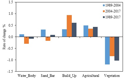
Land cover changes and land surface temperature have rose in the tropical regions of Myanmar especially in the surrounding areas of Magway city due to the rapid growth of urban sprawl. This study investigated the patterns of land cover and the trend of land surface temperature in Magway city area between 1989 and 2017. For this purpose, Landsat 5 TM and Landsat 8 OLI were used and land surface temperatures (LST) were calculated through thermal data with Normalized Difference Vegetation Index (NDVI). After obtaining the land cover map by using maximum likelihood algorithm for each study period, the accuracy of this map was tested using 100 ground checkpoints in an error matrix. A statistical analysis of the results showed the increase of the built-up area by 11.7% and the decline of the vegetation area by 19.7% from 1989 to 2017. Moreover, land surface temperature has risen by 4 °C during this 28 years period. Therefore, this study is intended to help the Magway city development council plan effective land cover management in the future.
Article Details
Published articles are under the copyright of the Environment and Natural Resources Journal effective when the article is accepted for publication thus granting Environment and Natural Resources Journal all rights for the work so that both parties may be protected from the consequences of unauthorized use. Partially or totally publication of an article elsewhere is possible only after the consent from the editors.
References
2. Alavipanah S, Wegmann M, Qureshi S, Weng Q, Koellner T. The role of vegetation in mitigating urban land surface temperatures: A case study of Munich, Germany during the warm season. Sustainability 2015;7(4):4689-706.
3. Artis DA, Carnahan WH. Survey of emissivity variability in thermography of urban areas. Remote Sensing of Environment 1982;12(4):313-29.
4. Bharath S, Rajan KS, Ramachandra TV. Land surface temperature responses to land use land cover dynamics. Geoinformatics Geostatistics: An Overview. 2013;1(4):1-10.
5. Cansong L, Lede N. Analysis on spatial-temporal distribution patten and change characteristics of land cover in Burma based on high-resolution remote sensing image and GIS technology. Proceedings of the 7th International Conference on Intelligent Computation Technology and Automation; 2014 Oct 25-26; Changsha: China; 2014.
6. Chander G, Markham B. Revised Landsat-5 TM radiometric calibration procedures and postcalibration dynamic ranges. IEEE Transactions on Geoscience and Remote Sensing 2003; 41(11):2674-7.
7. Chen YC, Chiu HW, Su YF, Wu YC, Cheng KS. Does urbanization increase diurnal land surface temperature variation? Evidence and implications. Landscape and Urban Planning 2017;157:247-58.
8. Cheruto MC, Kauti MK, Kisangau DP, Kariuki PC. Assessment of land use and land cover change using GIS and remote sensing techniques: A case study of Makueni County, Kenya. Journal of Remote Sensing and GIS 2016;5:1-6.
9. Gebrekidan, Werku. Modeling land surface temperature from satellite data, the case of Addis Ababa. Proceedings of the United Nations Conference Centre Addis Ababa; 2016 Sep 23-24; Africa Hall, Addis Ababa: Ethiopia; 2016.
10. Gibson PJ, Power CH. Introductory Remote Sensing: Digital Image Processing and Applications. London, United Kingdom: Routledge; 2000.
11. Gong P, Wang J, Yu L, Zhao Y, Zhao Y, Liang L, Niu Z, Huang X, Fu H, Liu S, Li C. Finer resolution observation and monitoring of global land cover: First mapping results with Landsat TM and ETM+ data. International Journal of Remote Sensing 2013;34(7):2607-54.
12. Jiménez-Muñoz JC, Sobrino JA. Split-window coefficients for land surface temperature retrieval from low-resolution thermal infrared sensors. IEEE Geoscience and Remote Sensing Letters 2008;5(4):806-9.
13. Jung M, Henkel K, Herold M, Churkina G. Exploiting synergies of global land cover products for carbon cycle modeling. Remote Sensing of Environment 2006;101(4):534-53.
14. Lambin EF, Geist HJ, Lepers E. Dynamics of land-use and land-cover change in tropical regions. Annual Review of Environment and Resources 2003;28(1):205-41.
15. Lambin EF, Geist HJ. Land-Use and Land-Cover Change: Local Processes and Global Impacts. Heidelberg, Germany: Springer; 2008.
16. Lambin EF. Modelling and monitoring land-cover change processes in tropical regions. Progress in Physical Geography 1997;21(3):375-93.
17. Lee TW, Lee JY, Wang ZH. Scaling of the urban heat island intensity using time-dependent energy balance. Urban Climate 2012;2:16-24.
18. Lillesand T, Kiefer RW, Chipman J. Remote Sensing and Image Interpretation. Hoboken, New Jersey, USA: John Wiley and Sons; 2015.
19. Markham BL. Landsat MSS and TM post-calibration dynamic ranges, exoatmospheric reflectances and at-satellite temperatures. Landsat Technical Notes 1986;1:3-8.
20. Meyer WB, Turner BL. Human population growth and global land-use/cover change. Annual Review of Ecology and Systematics 1992;23(1):39-61.
21. Nichol JE, To PH. Temporal characteristics of thermal satellite images for urban heat stress and heat island mapping. ISPRS Journal of Photogrammetry and Remote Sensing 2012;74(1):153-62.
22. Orhan O, Yakar M. Investigating land surface temperature changes using Landsat data in Konya, Turkey. International Archives of Photogrammetry, Remote Sensing and Spatial Information Sciences 2016;41:285-89.
23. Pu R, Gong P, Michishita R, Sasagawa T. Assessment of multi-resolution and multi-sensor data for urban surface temperature retrieval. Remote Sensing of Environment 2006;104(2):211-25.
24. Rujoiu-Mare MR, Mihai BA. Mapping land cover using remote sensing data and GIS techniques: A case study of Prahova Subcarpathians. Procedia Environmental Sciences 2016; 32:244-55.
25. Schowengerdt RA. Remote sensing: Models and methods for image processing. California, USA: Elsevier; 2006.
26. Shiferaw A, Singh KL. Evaluating the land use and land cover dynamics in Borena Woreda South Wollo Highlands, Ethiopia. Ethiopian Journal of Business and Economics (The) 2011;(2)1:69-104.
27. Singh R, Grover A, Zhan J. Inter-seasonal variations of surface temperature in the urbanized environment of Delhi using Landsat thermal data. Energies 2014;7(3):1811-28.
28. Sinha S, Sharma LK, Nathawat MS. Improved land-use/land-cover classification of semi-arid deciduous forest landscape using thermal remote sensing. Egyptian Journal of Remote Sensing and Space Science 2015;18(2):217-33.
29. Sobrino JA, Jimenez-Munoz JC, Paolini L. Land surface temperature retrieval from LANDSAT TM 5. Remote Sensing of environment 2004;90(4):434-40.
30. Tucker CJ. Red and photographic infrared linear combinations for monitoring vegetation. Remote Sensing of Environment 1979;8(2):127-50.
31. Voogt JA, Oke TR. Thermal remote sensing of urban climates. Remote Sensing of Environment 2003;86(3):370-84.
32. Wang S, Ma Q, Ding H, Liang H. Detection of urban expansion and land surface temperature change using multi-temporal Landsat images. Resources, Conservation and Recycling 2018;128:526-34.
33. Zhang F, Tiyip T, Kung H, Johnson VC, Maimaitiyiming M, Zhou M, Wang J. Dynamics of land surface temperature (LST) in response to land use and land cover (LULC) changes in the Weigan and Kuqa river oasis, Xinjiang, China. Arabian Journal of Geosciences 2016;9(7):499.
34. Zhang Y, Odeh IO, Ramadan E. Assessment of land surface temperature in relation to landscape metrics and fractional vegetation cover in an urban/peri-urban region using Landsat data. International Journal of Remote Sensing 2013;34(1): 168-89.