Spatial and Temporal Changes of Sundarbans Reserve Forest in Bangladesh
Article Sidebar
Published:
Mar 23, 2017
Keywords:
Bangladesh Geographic Information System (GIS) Land cover change Remote sensing Sundarbans reserved forest Sundarbans mangrove forest
Main Article Content
Abstract
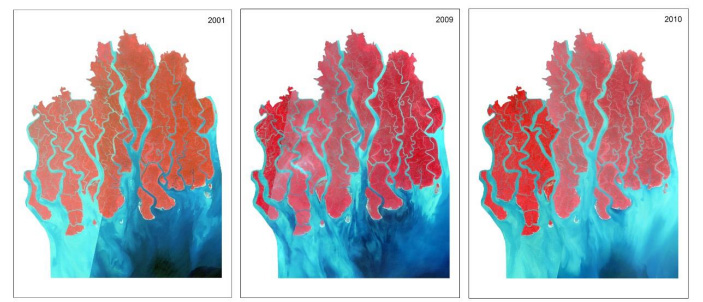
Sundarbans, the largest mangrove chunk of the world is shared between Bangladesh (62%) and India (38%). The objective of this paper was to examine the spatial and temporal changes in land cover (forest cover area) of Sundarbans from 1973 to 2010 using remote sensing and geographic information system (GIS) tool. Normalized difference vegetation index (NDVI) was applied to calculate the density of vegetation of Sundarbans reserved forest (SRF). This study found that there were no major changes in total areas of SRF in the last 37 years (from 1973 to 2010) albeit changes were detected within the four land cover categories-water body, mudflat, barren land and vegetated land. During 1973 to 2010, water bodies, mudflats and barren lands increased by 0.45%, 19.69% and 14.81%, respectively, while vegetated land decreased by 4.01% during the same period. This indicated that the density of evergreen vegetation and its canopy closure decreased in Sundarbans. It was thus recommended that GIS and remote sensing based real time monitoring system be developed to identify spatial and temporal changes of land cover classes of SRF.
Article Details
How to Cite
Haque Mondal, S., & Debnath, P. (2017). Spatial and Temporal Changes of Sundarbans Reserve Forest in Bangladesh. Environment and Natural Resources Journal, 15(1), 51–61. Retrieved from https://ph02.tci-thaijo.org/index.php/ennrj/article/view/80744
Section
Original Research Articles
Published articles are under the copyright of the Environment and Natural Resources Journal effective when the article is accepted for publication thus granting Environment and Natural Resources Journal all rights for the work so that both parties may be protected from the consequences of unauthorized use. Partially or totally publication of an article elsewhere is possible only after the consent from the editors.