
The Potential Surface Analysis (PSA) for Agricultural Community Development in Pa Phai Sub-district Municipality, San Sai District, Chiang Mai
Article Sidebar
Main Article Content
Abstract
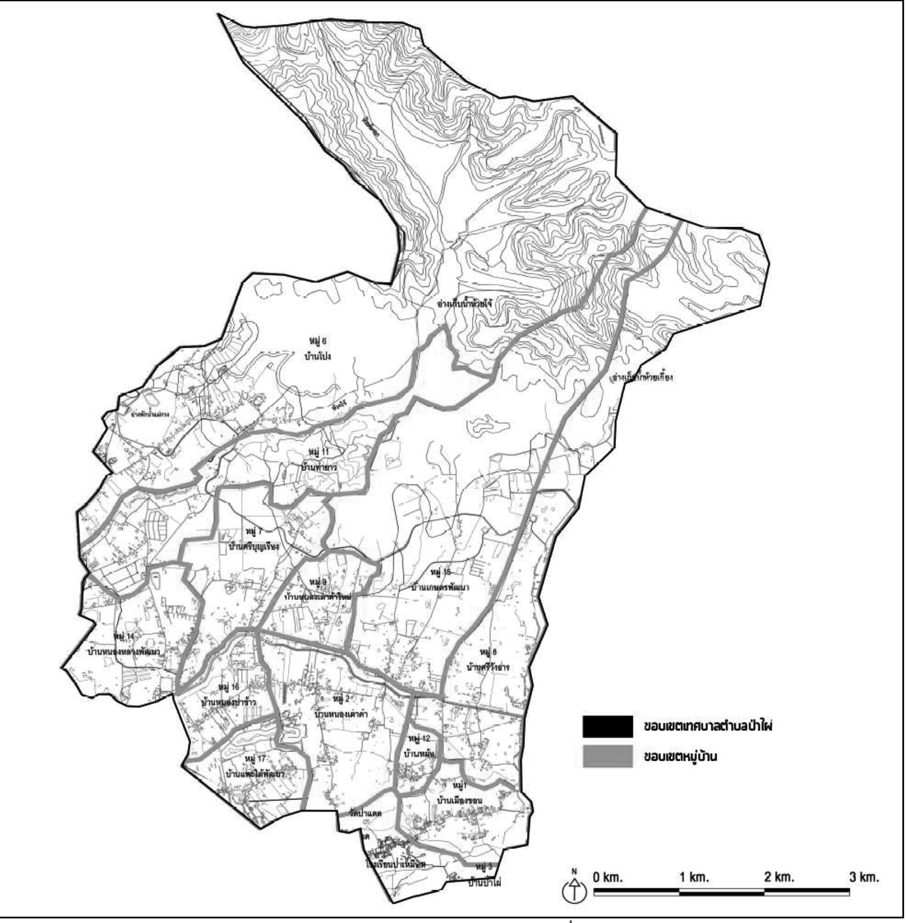
This research aims to study the spatial potential of Pa Phai Sub-district Municipality for the community development planning according community context, including submit land use guidelines for community development according the spatial potential for sustainable community development. The research methodology includes field surveys and secondary data collection. The potential of land use was then analyzed by Potential Surface Analysis (PSA). The research found that Pa Phai Sub-district Municipality is a semi rural-urban community and can be identified as a the agricultural community. There are physical conditions that are suitable for agriculture, especially in the central and southern areas that are suitable for rice farming because of the water supply and irrigation systems. The uplands are suitable for growing dry crops, perennial crops and horticulture. The high potential areas are suitable for agriculture, along the Mae Faek irrigation canal and the southern and west of the study areas should be preserved as agricultural areas with rural residential and commercial land uses. The high potential areas are suitable for residential area in the western and central part of Pa Phai Sub-district Municipality. The northern areas should be reserved for environmental and forest conservation land use and the continuous areas in the lower part should be preserved as the buffer zone for environmental conservation. These will encourage sustainable agricultural community development.
Downloads
Article Details

This work is licensed under a Creative Commons Attribution-NonCommercial-NoDerivatives 4.0 International License.
All material is licensed under the terms of the Creative Commons Attribution 4.0 International (CC-BY-NC-ND 4.0) License, unless otherwise stated. As such, authors are free to share, copy, and redistribute the material in any medium or format. The authors must give appropriate credit, provide a link to the license, and indicate if changes were made. The authors may do so in any reasonable manner, but not in any way that suggests the licensor endorses you or your use. The authors may not use the material for commercial purposes. If the authors remix, transform, or build upon the material, they may not distribute the modified material, unless permission is obtained from JARS. Final, accepted versions of the paper may be posted on third party repositories, provided appropriate acknowledgement to the original source is clearly noted.
References
Ativitavas, P., & Thongsukplang, S. (2006). Potential Surface Analysis (PSA) for Urban Development in Samutsakorn, Nakorn pathom, Samutsongkram, Petchaburi and Huahin, Prajuabkirikhan. Journal of Architectural/Planning Research and Studies, 4, 37-50.
Banthaothuk, P. (2014). Patterns of Agricultural Land Use and Oil Palm Production System: A Case Study of Klong Plu Sub-district, Nong Yai District, Chon Buri Province. Journal of Humanities and Social Sciences, Burapha University, 22(40), 43-63.
Bhandhasu, E., & Bejrananda, M. (2011). Travel behavior in regional city: A case study of Chiang Mai city. Journal of Faculty of Architecture Khon Kaen University, 10, 74-91.
Bunyapravitra, T. (2012). Urban Design and Planning for sustainable according to Smart Growth principles. Retrieved July 30, 2012, Retrieved December 5, 2013, from http://asiamuseum.co.th/upload/forum/SmartGrowLong.pdf
Deadman, P., Robinson, D., Moran, E., & Brondizio, E. (2004). Colonist household decisionmaking and land-use change in the Amazon Rainforest: an agent-based simulation. Environment and Planning B: Planning and Design, 31, 693-709. Retrieved December 5, 2013, from http://www.indiana.edu/~act/files/publications/2004/04-08_ColonistHouseholdDecisionmaking.pdf
Delbecq, Andre L., Van de Ven, Andrew H. & Gustafson, Harold A. (1975). Group techniques for program planning: a guide to nominal group and delphi processes. Glenview, IL: Scott.
Department of Public Works and Town & Country Planning. (2008). The study of the standard model used in the analysis for the comprehensive plan. Bangkok: Department of Public Works and Town & Country Planning.
Department of Public Works and Town & Country Planning. (2006). Criteria and Standards for Comprehensive Plan, Bangkok: Department of Public Works and Town & Country Planning.
Department of Public Works Town & Country Planning. (2001). Criteria and Standards for Comprehensive Plan : Revised edition 2001. Bangkok: Department of Town and Country Planning.
Goldberg, M. A. (1974). Residential developer behavior: Some empirical findings. Land Economics, 50(1), 85-89.
Kuariyakul, S. (2001). Geographic Information Systems for Chiang Mai. Department of Geography, Faculty of Social Sciences, Chiang Mai University. Chiang Mai.
Lambin, E.F., Rounsevell, M.D.A., & Geist, H.J. (2000). Are agricultural land- use models able to predict changes in land-use intensity? Agriculture, Ecosystems and Environment. 82, 321-331. Retrieved December 5, 2013, from http://www.scencedirect/science/artcle/pii/S0167880900002358
Lanchanon, P. (2013). The Potential of Agricultural Lands for Conservation of Green Area in Chiang Mai City. Journal of Architectural/Planning Research and Studies, 10(2), 115-137.
Land Development Department. (2012). Soil Classifications. Retrieved January 15, 2012, Retrieved December 5, 2013, from http://www.ldd.go.th/menu_download/download-1.htm
Lee, L. (1979). Factors affecting land use change at the urban-rural fringe. Growth and Change, 10(4), 25-31
McHarg, Ian L. (1971). Design with Nature. New York: Doubleday/Natural History Press.
Mongkonviboon, P. (2010). Factors Affecting the Decision of Farmers Making on Fresh Pod Soybean Growing : A Case Study of Chiangmai Frozen Food Company, Public Limited. Special problem. (Master of Thesis). Faculty of Business Administration. Maejo University.
Nakya, S., Leopairojna, S. K, Rangsiraksa, L., & Silapathong, C. (2011). Use of Satellite Data and Potential Surface Analysis for Urban Expansion of Hua Hin Municipality, Prachuap Khiri Khan Province. Proceedings of 49th Kasetsart University Annual Conference: Architecture and Engineering, February 1-4, 409-418.
Nathalang, S. (1986). A spatial analysis of factors influencing farmland conversion in the Bangkok metropolitan area, Thailand. (Doctor of Philosophy) Oregon State University. Faculty of Geography.
Northam, R.M. (1975). Urban Geography. John Wiley and Sons, New York.
Pa Phai Subdistrict Municipality. (2013). Information of Pa Phai Subdistrict Municipality. Chiang Mai. Retrieved September 7, 2013, Retrieved December 5, 2013, from http://www.papaichiangmai.com/about.php?id
Peerapun, W. (2006). Potential Surface Analysis. Retrieved March 14, 2014, Retrieved December 5, 2013, from http://pioneer.chula.ac.th/~pwannasi/psa.pdf.
Peerapun, W. (2012). The technique of analysis for urban and regional planning. Bangkok: Jarunsanitwongkarnpim.
Phongpipattanapan, S. (1999). An Analysis of schools service areas using geographic information system : a case study of Amphoe Pak Phli, Changwat Nakhon Nayok. Thesis. Gradute School, Srinakharinwirot University, Prasarnmit Campus. Bangkok. (Thailand).
Srivanit, M. (2009). GIS-based Land Suitability Analysis for Transit Oriented Development (TOD): A Case Study of Mass Transit Station to Campus Community. Retrieved May 20, 2018, Retrieved from https://www.researchgate.net/publication/290396138_GIS-based_Land_Suitability_Analysis_for_Transit_Oriented_Development_TOD_A_Case_Study_of_Mass_Transit_Station_to_Campus_Community.
Sukpromsun, B. (2015). Potential Surface Analysis for Urban Expansion around University of Phayao. Journal of Science and Technology, 23(3), 432-445.
Thadanjti, S. (1996). The appropriate pattern and management of Bangkok green area. Final seminar: Methodology for implementation of urban planning in Thailand. Bangkok: Chulalongkorn University.
The Treasury Department. (2012). Summary of estimated land prices during 2012-2015 in Chiang Mai province. Retrieved March 2, 2012, Retrieved December 5, 2013, from http://www.treasury.go.th/internet/land/province_price.htm.
Yardmak, P., & Anukulyudhathon, E. (2013). The potential of Chiang Mai city to as a buffer zone outside the protected area of Doi Suthep – Pui national park. Proceedings of 49th Kasertsart University Annual Conference, February 1-4, (138-147). Bangkok, Thailand.