
A Land Use Plan for A Border Town : Case Study of Chiang Khong Border Town, Wiang Sub-district Municipality, Chiang Khong District, Chiang Rai Province
Article Sidebar
Main Article Content
Abstract
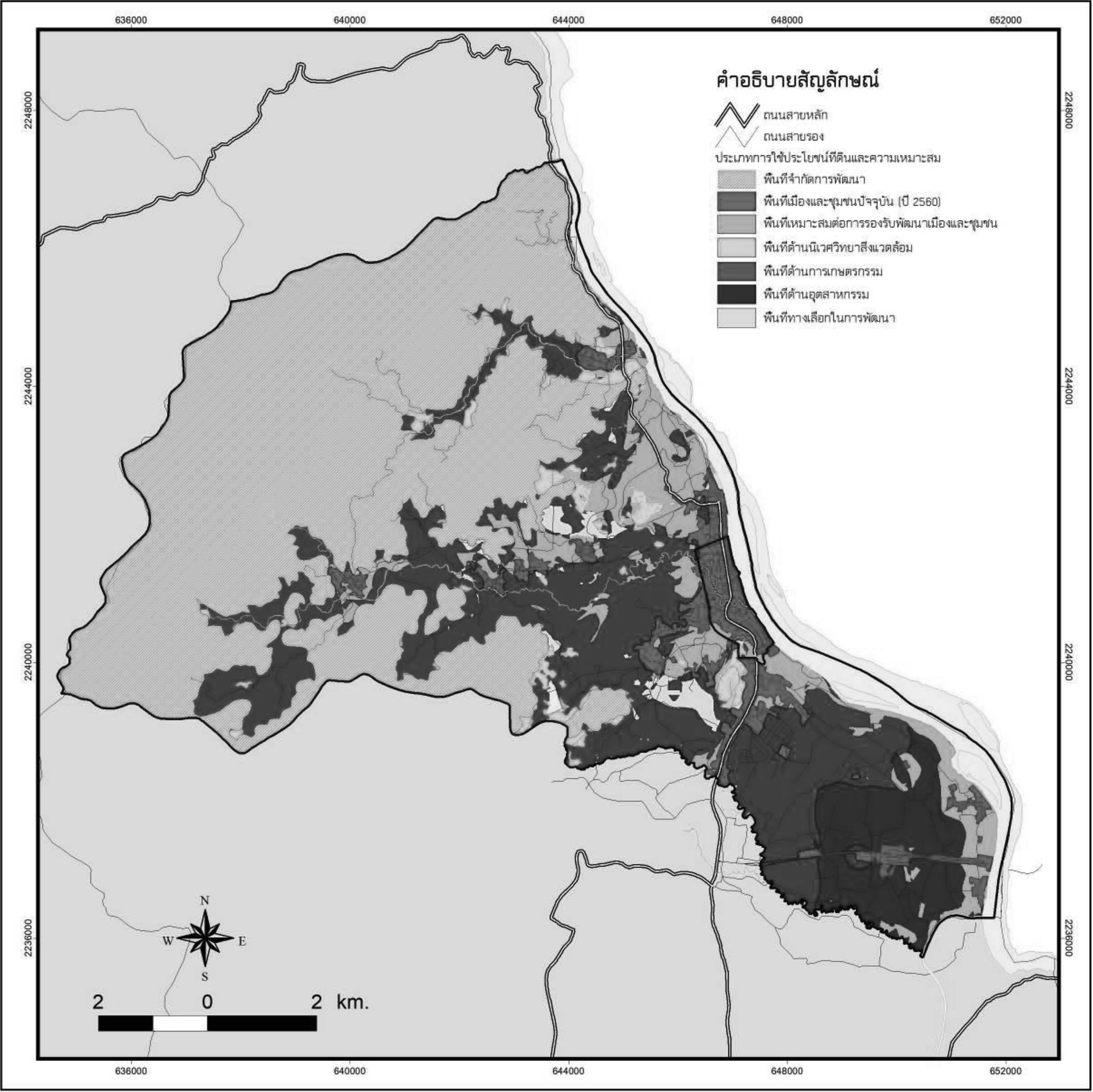
The main objective of this research was to study land use situation in Wiang Sub-district Municipality, Chiang Khong District, Chiang Rai Province. It also aimed to study land use problems and land use requirements from. This is to propose land use guidelines to solve Chiang Khong border town’s land use problems. Research methods comprised of surveying, interviewing and focused-group brainstorming. The study indicated that, land use in the area of Wiang sub-district Municipality faced external and internal changes, for instance: forest area reduction, the extended urban development at the southern area of Wiang sub-district municipality, illegal land ownership, encroachment of forest areas for agriculture, and under-utilized land. So, future land use plan should focus on land use control for both natural or environmental preservation and community growth.
Downloads
Article Details

This work is licensed under a Creative Commons Attribution-NonCommercial-NoDerivatives 4.0 International License.
All material is licensed under the terms of the Creative Commons Attribution 4.0 International (CC-BY-NC-ND 4.0) License, unless otherwise stated. As such, authors are free to share, copy, and redistribute the material in any medium or format. The authors must give appropriate credit, provide a link to the license, and indicate if changes were made. The authors may do so in any reasonable manner, but not in any way that suggests the licensor endorses you or your use. The authors may not use the material for commercial purposes. If the authors remix, transform, or build upon the material, they may not distribute the modified material, unless permission is obtained from JARS. Final, accepted versions of the paper may be posted on third party repositories, provided appropriate acknowledgement to the original source is clearly noted.
References
Department of Public Works and Town & Country Planning. (2013). Ban Phu Nam Ron Border Community Plan. Ban Kao Sub-district, Mueang Kanchanaburi District, Kanchanaburi Province. Retrieved Sep 19, 2017, from http://www.dpt.go.th/kanchanaburi/main/images/stories/pdf/28102014.pdf
Goodman, R., et al (2008). Identifying and Defining the Dimension of Community Capacity to Provide a Base for Measurement. Health Education & Behavior. 25(3), pp.258-278. Retrieved June 11, 2017, from https://www.ncbi.nlm.nih.gov/pubmed/9615238
Land Development Department. (2016). Geographic Information System (GIS). Bangkok: Land Development Department.
McHarg, I. L. (1971). Design with Nature. USA: Doubleday/Natural History Press.
Prescott, J.R.V. (1965). The Geography of Frontiers and Boundaries. Chicago: Aldine.
Raj Bala and Gopal Krishan. (1982). Urbanization in a Border Region: A Case Study of India’s Border Districts Adjoining Pakistan. The Geographical Journal Vol. 148, No. 1 (Mar., 1982), pp.43-49. Retrieved June 11,2017, from http://www.jstor.org/stable/634242.
Sariya Srichuae. (1997). Guidelines for the Main Commercial District Development in the Middle of the Bangkok : A Case study of Bang Kapi District. (Master of Urban and Regional Planning Thematic Paper). Chulalongkorn University, Faculty of Architecture.
Somjet Chantawat. (1981). Soil structure and management. Soil Journal. 7, pp.71-89.
Somjit Limsawatpon. (1995). Application of Geographic Information System for Land Use Planning at Trat Province. (Master of Urban and Regional Planning Thematic Paper). Chulalongkorn University, Faculty of Architecture.
Sudarat Auttarat. (2015). The Potentials Development of Local Administrative Government in Land Use Management with the Community Participation for Supporting ASEAN Economic Community. Bangkok: The Thailand Research Fund (TRF).
The Bureau of Registration Administration. (2016). The local area of Wiang Municipality Population, ChiangRai province. Bangkok: Department of Provincial Administration. Retrieved Sep 19, 2017, from http://stat.bora.dopa.go.th/stat/y_stat59.htm