
An Investigation of Buried Metal Object in High Electrical Conductivity Soil Layer Using Electrical Resistivity Survey Method
Article Sidebar
Main Article Content
Abstract
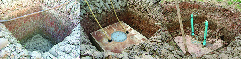
This study presents an investigation of buried metal object in Bangkok soft clay which has high electrical conductivity using electrical resistivity imaging (EI) as aimed to be applied for an application of underground infrastructures investigation planning and development such as gas pipeline, water line, or other buried metal objects. However, the electrical resistivity survey method has the best performance when applied over resistive terrain. This study, a metal cube about the size of 1 x 1 x 1 m was buried at 0.5 m-depth in the Bangkok soft clay ground. Afterward, 3D electrical resistivity imaging using pole-pole electrode configuration and 2D electrical resistivity imaging using Wenner electrode configuration had been performed to investigate a buried metal cube. The initial investigation result, 3D resistivity result hard to indicate buried metal object as it presents unclear shape. Next, the electrical wire was connected from buried object to the positive pole of the 12 v battery as aimed to make a contrast of electrical properties between the metal object and soft clay media. The final 3D resistivity result indicates the shape and position of buried metal more correctly. 2D resistivity imaging result at the initial stage indicates no buried metal object. After the buried metal object was connected to the battery, it has clearly identified in the 2D resistivity result.
Article Details
References
[2] John M. Reynolds. (2011). An Introduction to Applied and Environmental Geophysics. 2nd Edition Wiley-Blackwell
[3] Richard Van Blaricom. (1980). Practical Geophysics for the Exploration Geologist. Northwest Mining Association (U.S.)
[4] Loke, M. H. (2018). Tutorial: 2-D and 3-D Electrical Imaging Surveys. Access (27 July 2018). Available (http://www.geotomosoft.com)
[5] David, J. Daniels. (2004). Ground Penetrating Radar. 2nd Edition. The Institution of Electrical Engineers, London, United Kingdom
[6] Birstow, C.S. and Jol, H. M. (2003). Ground Penetrating Radar in Sediments. The Geological Society Publication No. 211, London
[7] Topp, G. C., Davis, J. L., and Annan, A. P. (1980). Electromagnetic Determination of Soil Water Content: Measurement in Coaxial Transmission Line. Water Resources Research. Vol. 16, pp. 574-582. DOI: 10.1029/WR016i003p00574
[8] Öz Yilmaz. (2001). Seismic Data Analysis: Processing, Inversion, and Interpretation of Seismic Data. Society of Exploration Geophysicists. p. 2065
[9] Paranis, D. S. (1973). Methods in Geochemistry and Geophysics, 3, The Mise-A-La-Masse Method, Mining Geophysics, 2nd Revised Edition, pp. 195-202
[10] Paranis, D. S. (1967). Three-Dimensional Electric Mise‐A‐La‐Masse Survey of An Irregular Lead‐Zine‐Copper Deposit in Central Sweden. The 29th Meeting of the European Association of Exploration Geophysicists Held in Stockholm. DOI: 10.1111/j.1365-2478.1967.tb01796.x
[11] Dinesh, G., Radhe, S., Agarwal, A. K., Bhattacharya, B. B., and Banerjee, B. (1999). Principles of Mise-A-La-Masse Method and its Application to Polymetallic Sulphide Deposits of
Rajasthan. Journal of Geological Society of India. Vol. 53, Issue 1, pp. 49-57
[12] Beasley, C. W. and Ward, S. W. (1986). Three Dimensional Mise-A-La-Masse Modeling Applied to Mapping Fracture Zones. Geophysics. Vol. 51, pp. 98-111
[13] Wightman, W. E., Jalinoos, F., Sirles, P., and Hanna, K. (2003). Application of Geophysical Methods to Highway Related Problems. Federal Highway Administration, Central Federal
Lands Highway Division, Lakewood, CO, Publication No. FHWA-IF-04-021
[14] Ping, D., Jingliang, F., Zhengzhou, C., Liangshu, W., Xinnan, G., and Ran, Q. (2008). Applying Mise-A-La-Masse Method to Determine the Length of Reinforcement in Bored In
Situ Concrete Piles. Journal of Environmental and Engineering Geophysics. Vol. 13, No. 2, pp. 51-56.
[15] Palacky, G. J. (1987). Resistivity Characteristics of Geologic Targets. Electromagnetic Methods in Applied Geophysics. Publisher: Society of Exploration Geophysicists Tulsa Vol. 1, pp. 53-129
[16] Schlumberger, C. (1920). Etude Sur la Prospection Electrique Du Sous-Sol. Gauthier-Villars, Paris, p. 94
[17] Loke, M. H. (2004). RES3DINV Version 2.14. Access (27 July 2018). Available (http://www.geotomosoft.com)
[18] Loke, M. H. (2004). RES2DINV Version 3.54. Access (27 July 2018). Available (http://www.geotomosoft.com)